In order to use this website you need to accept the use of Cookies , our Privacy Policy , and our Terms and Conditions.
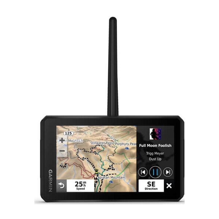
Garmin Tread M-S Off Road GPS
R15,989.00
SKU
010-02406-10
Easily sync your devices Mounts with muscle Abc sensors


Description
Keep your crew together with Garmin Tread M-S Off Road GPS group tracking for up to 20 riders, plus location sharing. Take your side-by-side off the beaten path with topo mapping and Tracks4Africa. The rugged Tread off-road GPS is IPX7 weather resistant and features a glove-friendly 5.5 touchscreen display.
Use the Tread app to sync data across your various devices. Direct-to-device BirdsEye Satellite Imagery can be downloaded to Tread without a computer. Easily install on your powersport vehicle with the included powered mount and wiring harness with tube mount.
Features
- Easily sync your devices
- Mounts with muscle
- Abc sensors
- Inreach compatible
- Go-anywhere guidance
- Live weather
- Travelling music
Specifications
| Physical dimensions | 5.8 W x 3.5 H x 1 D (8.8 x 14.8 x 2.4 cm) |
| Display size | 4.8 W x 2.7 H (12.1 x 6.8 cm) 5.5 diagonal (13.9 cm) |
| Display resolution | 1280 x 720 pixels |
| Display type | Multi-touch, glass, high brightness HD colour TFT with white backlight |
| Dual-orientation display | Yes |
| Weight | 9.2 oz (262 g) |
| Battery type | Rechargeable lithium-ion |
| Battery life | Up to 6 hours (up to 3.5 hours at 100% backlight) |
| Water rating | IPX7 |
| Drop rating | MIL-STD-810 |
| Tube mount (1.5 2.375) | Yes |
| 1 ball adapter with amps plate | Yes |
| Preloaded street maps | Yes |
| Data cards | YesmicroSD card (not included) |
| 3d terrain | Yes |
| Internal storage | 32 GB |
| Ability to add maps | Yes |
| Storage and power capacity | Yes (256 GB max microSD card) |
| Includes map updates | Yes |
| Downloadable satellite imagery | yes (BirdsEye) |
| Gps | Yes |
| Galileo | Yes |
| Barometric altimeter | Yes |
| Compass | Yes |
| Point-to-point navigation | Yes |
| Preloaded topographical maps | Yes |
| Navigate-a-track navigation | Yes |
| Backup camera compatible | Yes (BC 40) |
| Garmin real directions landmark guidance | Yes |
| Tripadvisor traveller ratings | Yes |
| Route shaping through preferred cities/streets | Yes |
| Traffic updates | Yes (with Garmin Tread app) |
| Lane assist with junction view (displays junction signs) | Yes |
| Speed limit indicator (displays speed limit for most major roads in the u.s. and europe) | Yes |
| Bluetooth Calling | Yes (works with Bluetooth-compatible helmet, headset or smartphone BLE capable) |
| Driver alerts for sharp curves, school zones, red light and speed camera warnings and more | Yes |
| Smart notifications via app | Yes |
| Wi-fi map and software updates | Yes |
| Access to live services via app | Yes |
| Pair with compatible inreach devices | Yes |
| Pair with garmin powerswitch | Yes |
| Compatible with group ride tracker | Yes (included) |
| Track recorder (breadcrumbs) | Yes |
| Ioverlander points of interest | Yes |
| Pitch and roll gauges | Yes |
| Radio frequency band | VHF 169.4125/169.4250/169.4375/169.4500/169.4625 MHz |
| Group ride range | Up to 8 miles (13 kilometres) with the antenna mount kit |
| Group ride tracking | Up to 20 riders simultaneously |
| Group ride update rate | 5 seconds |
| Radio transmitted canned messages | Yes |
| Free Shipping | No |
|---|
Write Your Own Review
Customer Questions