In order to use this website you need to accept the use of Cookies , our Privacy Policy , and our Terms and Conditions.
Garmin 67 Handheld GPS
R12,569.00
SKU
010-02813-01
- Stay tuned to the forecast
- See your route clearly on the 3″ sunlight-readable colour display
- See the terrain you’ll travel with vivid satellite imagery


Description
Introducing the Garmin 67 Handheld GPS, a feature-packed navigation device that empowers outdoor enthusiasts with exceptional functionality and durability for their adventures.
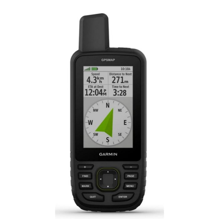
With its 3-inch sunlight-readable colour display, the Garmin 67 provides a clear and vivid view of your route. Say goodbye to squinting or struggling to read your screen in bright sunlight. The high-resolution display ensures that you can easily track your progress, view maps, and navigate with confidence, even in challenging lighting conditions.
Don't let battery life limit your exploration. The Garmin 67 is designed to keep up with your extended journeys. With up to 180 hours of battery life in tracking mode and an impressive 840 hours in expedition mode, this handheld GPS ensures that you have ample power to tackle long expeditions, extended hikes, or any outdoor activity without the need for frequent recharging. Travel with peace of mind, knowing that your device can keep up with your adventures.
Tracking your position accurately is essential, especially in challenging conditions. The Garmin 67 is equipped with multi-band technology and expanded GNSS support, including GPS, GLONASS, and Galileo. This comprehensive positioning system ensures that you can confidently track your position, even in remote or obstructed areas. Whether you're exploring dense forests, deep canyons, or navigating urban environments, the Garmin 67 provides reliable and precise navigation information.
To enhance your navigation experience, the Garmin 67 allows you to see the terrain you'll travel with vivid satellite imagery. By downloading satellite imagery directly to your navigator, you can gain a visual understanding of the landscape, including topographical features, vegetation, and landmarks. This valuable information helps you plan your routes, anticipate challenges, and make informed decisions, ensuring a successful and enjoyable outdoor experience.
Stay updated on the forecast with active weather on your route when the Garmin 67 is paired with your compatible smartphone. By leveraging the power of your smartphone and utilizing the Garmin Connect app, you can receive real-time weather updates, including alerts, forecasts, and radar images. This valuable information allows you to adjust your plans, take necessary precautions, and stay safe in changing weather conditions.
In summary, the Garmin 67 Handheld GPS is a reliable and versatile companion for outdoor enthusiasts seeking advanced navigation capabilities. With its sunlight-readable colour display, impressive battery life, multi-band technology, expanded GNSS support, vivid satellite imagery, and active weather integration, this handheld GPS ensures that you have the tools necessary to navigate with confidence, explore the terrain, and stay informed about changing conditions during your outdoor adventures.
Features
- See your route clearly on the 3 sunlight-readable colour display
- Travel longer with up to 180 hours of battery life in tracking mode and up to 840 hours in expedition mode
- Stay tuned to the forecast
- See the terrain youll travel with vivid satellite imagery
Specifications
| General | |
| Dimension | 6.2 x 16.3 x 3.5 cm (2.5 x 6.4 x 1.4) |
| Display Size | 3.8 x 6.3 cm (1.5W x 2.5H ) 7.6 cm diag (3) |
| Display Resolution | 240 x 400 pixels |
| Display Type | Transflective colour TFT |
| Weight | 230 g with batteries |
| Water Rating | IPX7 |
| Battery Type | Rechargeable, internal lithium-ion |
| Battery Life | |
| Default Mode | Up to 180 hours |
| Expedition Mode | Up To 840 Hours |
| Mil-Std-810 | Yes (thermal, shock, water) bare unit only |
| Interface | USB-C |
| Memory/History | 16 GB (user space varies based on included mapping) |
| Maps And Memory | |
| Preloaded Maps | Yes (TopoActive Europe, routable) |
| Ability To Add Maps | Yes |
| Basemap | Yes |
| Automatic Routing (Turn By Turn Routing On Roads) For Outdoor Activities | Yes |
| Map Segments | 15,000 |
| Satellite Imagery | Yes (direct to device) |
| Includes Detailed Hydrographic Features (Coastlines, Lake/River Shorelines, Wetlands And Perennial And Seasonal Streams) | Yes |
| Includes Searchable Points Of Interests (Parks, Campgrounds, Scenic Lookouts And Picnic Sites) | Yes |
| Displays National, State And Local Parks, Forests, And Wilderness Areas | Yes |
| Storage And Power Capacity | Yes (32 GB max microSD card) |
| Waypoints/Favourites/Locations | 10,000 |
| Courses | 250, 200 course points per course |
| Tracks | 250 |
| Navigation Track Log | 20,000 points, 250 saved gpx tracks, 300 saved fit activities |
| Activities | Yes |
| Navigation Routes | 250, 250 points per route 50 points auto routing |
| Sensor | |
| High-Sensitivity Receiver | Yes |
| Gps | Yes |
| Glonass | Yes |
| Galileo | Yes |
| Qzss | Yes |
| Beidou | Yes |
| Irnss | Yes |
| Barometric Altimeter | Yes |
| Compass | Yes (tilt-compensated 3-axis) |
| Gps Compass (While Moving) | Yes |
| Multi-Band Frequency | Yes |
| Daily Smart Feature | |
| Connect Iq (Downloadable Watch Faces, Data Fields, Widgets And Apps) | Yes |
| Smart Notifications On Handheld | Yes |
| Virb Camera Remote | Yes |
| Compatible With Garmin Connect Mobile | Yes |
| Active Weather | Yes |
| Safety And Tracking Feature | |
| Livetrack | Yes |
| Outdoor Recreation | |
| Point-To-Point Navigation | Yes |
| Tracback | Yes |
| Area Calculation | Yes |
| Hunt/Fish Calendar | Yes |
| Sun And Moon Information | Yes |
| Xero Locations | Yes |
| Geocaching-Friendly | Yes (Geocache Live) |
| Custom Maps Compatible | Yes (500 custom map tiles) |
| Picture Viewer | Yes |
| Led Beacon Flashlight | Yes |
| Inreach Feature | |
| Inreach Remote Compatible | Yes |
| Outdoor Applications | |
| Compatible With Garmin Explore App | Yes |
| Garmin Explore Website Compatible | Yes |
| Connection | |
| Connections Wireless Connectivity | Yes (Wifi, Bluetooth, ANT+) |
| Free Shipping | No |
|---|
Write Your Own Review
Customer Questions