In order to use this website you need to accept the use of Cookies , our Privacy Policy , and our Terms and Conditions.
Garmin eTrex Touch Handheld GPS With Touchscreen And Preloaded Maps
R10,379.00
SKU
010-02940-01
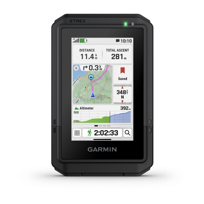
Swipe and zoom on a bright 3 touchscreen
Preloaded maps for roads and trails
Long battery life of up to 130 hours in gps mode
Built tough (mil-std 810) and weather-resistant (ip67)


Manufacturer's Website
Description
Introducing the Garmin eTrex Touch Handheld GPS With Touchscreen And Preloaded Maps. A versatile and user-friendly navigation device designed for outdoor enthusiasts who want reliable performance combined with advanced mapping and touchscreen convenience. Engineered for hiking, camping, mountain biking, geocaching, overlanding, and outdoor exploration, this handheld GPS delivers accurate navigation with preloaded TopoActive maps that include routable roads and trails. Its intuitive touchscreen interface allows users to swipe, zoom, and interact with maps effortlessly, making trip planning and navigation more efficient and enjoyable even while on the move.
Built to handle demanding outdoor environments, the Garmin eTrex Touch features a rugged design that meets MIL-STD 810 durability standards and carries an IP67 water-resistance rating. This construction helps protect the device against dust, rain, splashes, and harsh weather conditions encountered during outdoor adventures. The navigator includes a bright 3-inch transflective colour TFT display with a resolution of 240 x 400 pixels, providing clear visibility in both direct sunlight and shaded conditions. Protected by chemically strengthened glass, the screen is designed to withstand rough handling while maintaining excellent touch responsiveness. Despite its durable construction, the device remains lightweight at only 150 grams, making it easy to carry during long hikes or extended expeditions.
Navigation accuracy and mapping capabilities are among the standout features of this handheld GPS. The device supports multiple satellite navigation systems, including GPS, GLONASS, Galileo, QZSS, BeiDou, and IRNSS, along with multi-band frequency support for improved accuracy in difficult terrain such as forests, mountains, and urban environments. The integrated barometric altimeter and electronic compass provide precise elevation and directional data, helping users maintain orientation during outdoor activities. Preloaded TopoActive maps offer detailed information on roads, trails, coastlines, rivers, wetlands, parks, forests, campgrounds, scenic lookouts, and wilderness areas, giving adventurers a comprehensive navigation experience directly out of the box.
The Garmin eTrex Touch also provides excellent flexibility for advanced users who require customized navigation solutions. Users can add additional maps, import GPX files, create unlimited courses and activities, and store up to 15,000 map segments. The device supports custom maps with up to 500 map tiles and offers optional Outdoor Maps+ subscriptions for enhanced satellite imagery and premium mapping content. Turn-by-turn routing for outdoor activities makes trail navigation intuitive, while TracBack functionality allows users to retrace their routes safely back to their starting point. Geocaching support, sun and moon information, area calculation, and point-to-point navigation further enhance its value for recreational and professional outdoor use.
Battery performance is another major strength of the Garmin eTrex Touch. The rechargeable internal lithium-ion battery delivers up to 130 hours of operation when using all satellite systems with multi-band tracking enabled. Expedition mode extends battery life up to 650 hours, making the device suitable for multi-day trips and remote expeditions where charging opportunities may be limited. The inclusion of a USB-C interface ensures modern connectivity for charging and data transfer, while the generous 32 GB internal memory provides substantial storage space for maps, routes, activities, and navigation data.
Smart connectivity features help integrate the handheld navigator seamlessly into a connected outdoor lifestyle. The device supports wireless connectivity through Wi-Fi, Bluetooth Low Energy (BLE), and ANT technologies, enabling synchronization with the Garmin Explore smartphone app and Garmin Connect Mobile. Users can plan routes, review trips, access weather forecasts, receive smart notifications, and share data effortlessly between devices. Safety features such as LiveTrack allow friends and family to monitor a users progress during outdoor adventures, while Garmin Share simplifies data sharing with compatible devices. Additional tactical features, including dual grid coordinates, night vision mode, and optional ballistics support, further expand the navigators capabilities for specialized outdoor applications.
With its responsive touchscreen interface, advanced mapping functionality, long battery life, rugged durability, and extensive navigation tools, the Garmin eTrex Touch Handheld GPS offers a comprehensive solution for outdoor navigation. Whether navigating remote hiking trails, planning backcountry expeditions, exploring unfamiliar terrain, or participating in geocaching activities, this handheld GPS is designed to provide confidence, accuracy, and convenience for adventurers of all experience levels.
Features
- Swipe and zoom on a bright 3 touchscreen
- Preloaded maps for roads and trails
- Long battery life of up to 130 hours in gps mode
- Built tough (mil-std 810) and weather-resistant (ip67)
- Plan and review trips with the garmin explore smartphone app
- Option to purchase an outdoor maps+ plan for premium mapping
Specifications
| Brand | Garmin |
| General | |
| Lens Material | Chemically strengthened glass |
| Dimension | 66 mm x 105.4 mm x 24.6 mm (2.6 x 4.15 x 0.97) |
| Weight | 150 g (5.3 oz) |
| Water Rating | IP67 |
| Touchscreen | Yes |
| Display Type | 3 transflective colour TFT |
| Display Size | 3.88 cm x 6.48 cm (1.53 x 2.55) 7.62 cm (3) diag |
| Display Resolution | 240 x 400 pixels |
| Battery Type | Rechargeable, internal lithium-ion |
| Battery Life | |
| All Satellite Systems + Multi-Band | Up to 130 hours |
| Expedition Mode | Up To 650 Hours |
| Memory/History | 32 GB (user space varies based on included mapping) |
| Interface | USB-C |
| Maps & Memory | |
| Preloaded Maps | Yes (TopoActive, routable) |
| Ability To Add Maps | Yes |
| Basemap | Yes |
| Automatic Routing (Turn By Turn Routing On Roads) For Outdoor Activities | Yes |
| Map Segments | Yes (15,000) |
| Satellite Imagery | Yes (via Outdoor Maps+ subscription) |
| Includes Detailed Hydrographic Features (Coastlines, Lake/River Shorelines, Wetlands And Perennial And Seasonal Streams) | Yes |
| Includes Searchable Points Of Interests (Parks, Campgrounds, Scenic Lookouts And Picnic Sites) | Yes |
| Displays National, State And Local Parks, Forests, And Wilderness Areas | Yes |
| Waypoints | Yes |
| Courses | Unlimited |
| Activities | Unlimited |
| Activity Profiles | Yes |
| Gpx Imports | Yes |
| Sensors | |
| Gps | Yes |
| Glonass | Yes |
| Galileo | Yes |
| Qzss | Yes |
| Beidou | Yes |
| Irnss | Yes |
| Barometric Altimeter | Yes |
| Compass | Yes |
| High-Sensitivity Receiver | Yes |
| Gps Compass (While Moving) | Yes |
| Multi-Band Frequency | Yes |
| Daily Smart Features | |
| Connect Iq (Downloadable Watch Faces, Data Fields And Apps) | Yes |
| Smart Notifications On Handheld | Yes |
| Weather Forecasts | Yes |
| Weather (Removing Active) | Yes |
| Compatible With Garmin Connect Mobile | Yes |
| Garmin Share | Yes |
| Passcode | Yes |
| Next Word, Auto Complete, Auto Correct | Yes (auto correct, next word, auto complete) |
| Safety And Tracking Features | |
| Livetrack | Yes |
| Tactical Features | |
| Compatible With Ab Quantum - Garmin | Yes |
| Ballistics Solver | Yes (unlock required) |
| Dual Grid Coordinates | Yes |
| Night Vision Mode | Yes |
| Outdoor Recreation | |
| Point-To-Point Navigation | Yes |
| Tracback | Yes |
| Area Calculation | Yes |
| Sun And Moon Information | Yes |
| Geocaching-Friendly | Yes (Geocache Live) |
| Custom Maps Compatible | Yes (500 custom map tiles) |
| Picture Viewer | Yes |
| Outdoor Applications | |
| Compatible With Garmin Explore App | Yes |
| Garmin Explore Website Compatible | Yes |
| Networking & Connections | |
| Wireless Connectivity | Yes (Wi-Fi, BLE, ANT) |
Package Cotents
- 1x garmin etrex touch handheld gps with touchscreen and preloaded maps
- 1x type-c to type-c usb cable
- 1x documentation
| Free Shipping | No |
|---|
Write Your Own Review
Customer Questions