In order to use this website you need to accept the use of Cookies , our Privacy Policy , and our Terms and Conditions.
Garmin Montana 710i Touchscreen Handheld GPS With inReach Technology
R22,829.00
SKU
010-02964-02
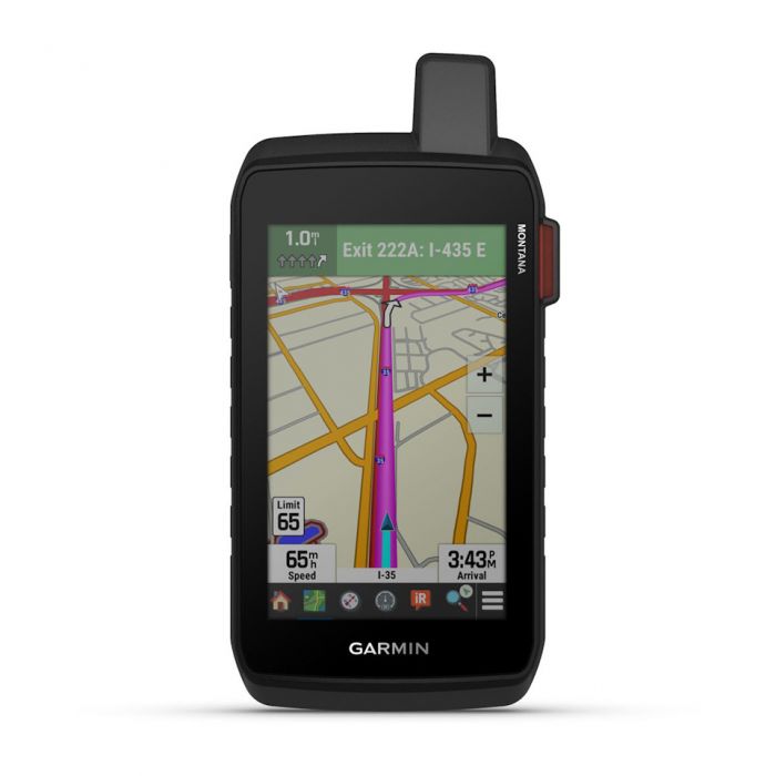
Large 5-inch glove-friendly touchscreen
Preloaded routable topographic maps with landmarks
Stay in touch with inreach messaging and 24/7 sos
Meets mil-std 810 for thermal, shock, water and vibration


Description
Introducing the Garmin Montana 710i Touchscreen Handheld GPS With inReach Technology. Combining rugged durability with advanced navigation and communication features, making it an ideal companion for outdoor enthusiasts, explorers, and professionals in demanding environments. Its large 5-inch glove-friendly touchscreen provides a clear, high-resolution display that is easy to operate in various conditions, supported by chemically strengthened glass for added durability. Built to withstand harsh conditions, it meets military standards (MIL-STD 810) for thermal, shock, water, and vibration resistance, and boasts an IPX7 water rating, ensuring reliable performance whether you're on foot, bike, kayak, ATV, or other outdoor pursuits.
Equipped with preloaded topographic maps and landmarks, the Garmin Montana 710i offers comprehensive routing capabilities for both outdoor and motorized vehicle use. Its detailed mapping includes hydrographic features, points of interest, parks, forests, and wilderness areas, with the ability to add additional maps via Wi-Fi or microSD card. Satellite imagery is directly accessible, providing vivid overhead views of your route and surroundings, greatly enhancing navigation accuracy and situational awareness in remote or unfamiliar terrain. The device supports extensive waypoint, course, and track management, enabling users to plan, track, and review their adventures with precision. One of the standout features of the Montana 710i is its integrated inReach technology, which provides two-way messaging, GPS tracking, and interactive SOS alerts. When connected via satellite, users can send and receive text messages, photos, and location data, even when off the grid. In emergency situations, the interactive SOS feature connects users to Garmin Response, a 24/7 global assistance center for rescue coordination. The devices long battery life-up to 24 hours in GPS mode and up to 440 hours in expedition mode-ensures continuous operation during extended trips, with the ability to power off for up to a year.
Additional smart features include compatibility with the Garmin Explore app, which enables trip planning, route sharing, and live tracking, making it easier to coordinate with friends or team members. The Montana 710i also supports smart notifications, weather forecasts, and Garmin Connect Mobile integration, adding convenience and safety. Its array of sensors-GPS, Galileo, barometric altimeter, tilt-compensated compass, and high-sensitivity receiver-delivers precise positioning and elevation data. With its robust construction, extensive mapping options, and advanced communication capabilities, the Garmin Montana 710i is an all-in-one navigation and safety solution tailored for serious outdoor adventures and professional use.
Features
- Large 5-inch glove-friendly touchscreen
- Preloaded routable topographic maps with landmarks
- Stay in touch with inreach messaging and 24/7 sos
- Meets mil-std 810 for thermal, shock, water and vibration
- Satellite imagery shows vivid overhead views of your route
- Supports outdoor maps+ for premium mapping (sold separately)
Specifications
| Brand | Garmin |
| General | |
| Lens Material | Chemically strengthened glass |
| Dimension | 9.19 x 18.30 x 3.27 cm (3.6 x 7.2 x 1.3) |
| Weight | 410g (14.5oz) with included lithium-ion battery pack |
| Water Rating | IPX7 |
| Mil-Std-810 | Yes (thermal, shock, water, vibe) |
| Touchscreen | Yes |
| Display Type | WVGA transflective, dual orientation |
| Display Size | 6.48 x 10.80 cm (2.55W x 4.25H) 12.70 cm (5 diag) |
| Display Resolution | 480 x 800 pixels |
| Battery Type | Rechargeable lithium-ion (included) |
| Battery Life | |
| GPS Mode | Up to 24 hours (including when a text message or location is sent every 10 minutes) |
| Expedition Mode | Up To 440 Hours Or Up To 300 Hours With A Text Message Or Location Sent Every 30 Minutes |
| Powered Off | Up To 1 Year |
| Note | Battery Life Estimates Are With Full Sky View And Can Be Significantly Impacted By Obstructions Or Tree Cover. |
| Memory/History | 32 GB (user space varies based on included mapping) |
| Interface | High-speed USB-C |
| Maps & Memory | |
| Preloaded Maps | Yes (TopoActive Australia, New Zealand & Africa City Navigator Australia, New Zealand & Africa - Additional regions can be downloaded over Wi-Fi) |
| Ability To Add Maps | Yes |
| Basemap | Yes |
| Automatic Routing (Turn By Turn Routing On Roads) For Outdoor Activities | Yes |
| Automatic Routing (Turn By Turn Routing On Roads) For Motorized Vehicles | Yes |
| Map Segments | 15 000 |
| Satellite Imagery | Yes (direct to device) |
| Includes Detailed Hydrographic Features (Coastlines, Lake/River Shorelines, Wetlands And Perennial And Seasonal Streams) | Yes |
| Includes Searchable Points Of Interests (Parks, Campgrounds, Scenic Lookouts And Picnic Sites) | Yes |
| Displays National, State And Local Parks, Forests, And Wilderness Areas | Yes |
| Storage And Power Capacity | Yes (32 GB max microSD card) |
| Waypoints/Favourites/Locations | 10 000 |
| Courses | 250, 200 course points per course |
| Tracks | 250 |
| Navigation Track Log | 20,000 points, 250 saved gpx tracks, 300 saved fit activities |
| Navigation Routes | 250, 250 points per route 50 points auto routing |
| Rinex Logging | Yes |
| Sensors | |
| Gps | Yes |
| Galileo | Yes |
| Barometric Altimeter | Yes |
| Compass | Yes (tilt-compensated 3-axis) |
| High-Sensitivity Receiver | Yes |
| Gps Compass (While Moving) | Yes |
| Daily Smart Features | |
| Connect Iq (Downloadable Watch Faces, Data Fields And Apps) | Yes |
| Smart Notifications On Handheld | Yes |
| Weather Forecasts | Yes |
| Weather (Removing Active) | Yes |
| Compatible With Garmin Messenger App | Yes |
| Virb Camera Remote | Yes |
| Compatible With Garmin Connect Mobile | Yes |
| Safety And Tracking Features | |
| Livetrack | Yes |
| Tactical Features | |
| Ballistics Solver | Yes |
| Xero Locations | Yes |
| Outdoor Recreation | |
| Point-To-Point Navigation | Yes |
| Tracback | Yes |
| Area Calculation | Yes |
| Fish Forecast | Yes |
| Sun And Moon Information | Yes |
| Geocaching-Friendly | Yes (Geocache Live) |
| Custom Maps Compatible | Yes (500 custom map tiles) |
| Picture Viewer | Yes |
| Led Beacon Flashlight | Yes |
| Inreach Features | |
| Interactive Sos | Yes |
| Weather (Removing Inreach) | Yes |
| Send And Receive Text Messages To Sms And Email | Yes |
| Send And Receive Text Messages To Other Inreach Device | Yes |
| Send And Receive Group Messages | Yes |
| Exchange Locations With Other Inreach Device | Yes |
| Mapshare Compatible With Tracking | Yes |
| Virtual Keyboard For Custom Messaging | Yes |
| Send Waypoints To Mapshare During Trip | Yes |
| Send Route Selection To Mapshare During Trip | Yes |
| Outdoor Applications | |
| Compatible With Garmin Explore App | Yes |
| Garmin Explore Website Compatible | Yes |
| Smart Switching Between Wi-Fi, Mobile And Satellite With Garmin Messenger App | Yes |
| Dog Tracking | Yes (when paired to compatible dog track system) |
| Networking & Connections | |
| Wireless Connectivity | Yes (Wi-Fi, BLUETOOTH, ANT+) |
Package Cotents
- 1x Garmin montana 710i rugged touchscreen handheld gps with inreach technology
- 1x High capacity lithium-ion battery pack
- 1x Usb cable (usb-c to usb-c)
- 1x Documentation
| Free Shipping | No |
|---|
Write Your Own Review
Customer Questions