In order to use this website you need to accept the use of Cookies , our Privacy Policy , and our Terms and Conditions.
Onwa Kcombo-7 Gps Chart Plotter With Fish Finder - 7-Inch, Plastic Mount
R13,679.00
SKU
KCOMBO7TransomTdxr
Navionics+
K-chart3.0
C-map max


Description
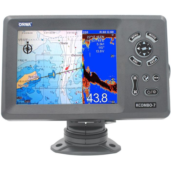
Introducing the Onwa Kcombo-7 GPS Chart Plotter With Fish Finder - 7-Inch, Plastic Mount. The Onwa KCombo-7 GPS Chart Plotter with Fish Finder is a comprehensive marine navigation system that integrates both chart plotting and fish finding functionalities into a single device. Featuring compatibility with K-Chart 2.0, K-Chart 3.0, C-Map Max, and Navionics+, it offers a versatile mapping system that supports various chart formats for enhanced navigation.
Equipped with a 7-inch Colour TFT day view LCD display with a resolution of 800x600 pixels, this device provides a clear and detailed view even under direct sunlight. The split-screen capability allows users to simultaneously view the GPS chart plotter and saved echo history, enhancing the fishing experience.
For chart plotting, it supports up to 12,000 user waypoints with names and symbols, 30 routes with up to 170 points each, and 8,000 points automatic track log. The plotter offers various alarms like XTE, anchor drag, arrival, speed, voltage, proximity waypoint, timer, and AIS alarms, ensuring safety and navigation efficiency.
The integrated fish finder comes with a transom-mounted dual-frequency plastic transducer (50 & 200kHz) featuring a nominal power output of 300W and a maximum power output of 600W. It offers comprehensive depth and range settings, supporting multiple ranges in meters, feet, fathoms, and passi/braza. The echo sounder has a range shift capability of up to 1000 meters and supports various display modes including High Frequency (200KHz), Low Frequency (50KHz), Dual, Zoom, and A-scope Display.
With a built-in GPS receiver featuring 50 parallel channels and support for GPS, Beidou, GLONASS, and Galileo satellite systems, this unit provides accurate positioning data and supports multiple GNSS systems. It allows for the reception and output of various NMEA sentences, providing extensive data connectivity.
The device is designed to withstand marine conditions, with the display unit and antenna unit rated at IP66 waterproofing. The system operates within a temperature range of -15C to +55C for the display unit and -25C to +70C for the antenna unit, making it suitable for various environmental conditions.
Features
- K-chart 2.0
- K-chart3.0
- C-map max
- Navionics+
- Split screen with GPS chart plotter
- Saves echo history
Specifications
| Plotter Characteristics | ||||||||||
| Waypoints/Icons | 12,000 user waypoints with name, symbol | |||||||||
| 3 system waypoints: MOB, Start, cursor | ||||||||||
| 10 proximity waypoints | ||||||||||
| Routes | 30 routes waypoint up to 170 points each, plus MOB and Track Navigation or Goto Track modes | |||||||||
| Tracks | 8,000 points automatic track log | |||||||||
| 10 saved tracks (up to 8000 track points each) lets you retrace your path in both directions | ||||||||||
| Alarms | XTE, Anchor drag, arrival, speed, voltage, proximity waypoint, Timer and AIS (CPA and TCPA) alarm | |||||||||
| Drawing | 1000 Drawing Marks, 2000 Drawing Lines (40 points each) | |||||||||
| 1000 Drawing Place Name, 8 colours for Drawing | ||||||||||
| Pallete | Normal | |||||||||
| Daylight exposed to sunlight | ||||||||||
| Night in dark environment | ||||||||||
| NOAA paperchart colours | ||||||||||
| Tides | Built-in Worldwide Tide Data | |||||||||
| Position Format | Lat/Lon | |||||||||
| Basemap | Worldwide | |||||||||
| External Map | Compatible with K-Chart 2.0, K-Chart 3.0, C-Map Max and Navionics+ | |||||||||
| User Data Storage | Internal backup of user settings or external SD-card | |||||||||
| Plot Interval | 5 secs to 60 mins or 0.01 to 10nm | |||||||||
| Plotting Scales | 0.001 to 700nm | |||||||||
| Perspective View | On/off (available for C-Map only) | |||||||||
| Celestial | Sunrise/Sunset Moonrise/Moonset | |||||||||
| GPS Receiver Characteristics | ||||||||||
| Receiver | 50 parallel channel GNSS receiver continuously tracks and uses up to 50 satellites to compute and update your position | |||||||||
| Acquisition Time | Cold start: 29 seconds | |||||||||
| Hot start: 1 second | ||||||||||
| Update Rate | 1 second or 0.1 second selectable | |||||||||
| Accuracy | Position:3 meters(95%) without S/A | |||||||||
| Velocity: 0.1 meter/sec without S/A | ||||||||||
| Sbas | Supported | |||||||||
| Qzss | Supported | |||||||||
| Satellite System | Choice of 4 GNSS: GPS, Beidou, GLONASS and Galileo | |||||||||
| Dynamics | Altitude: 18,000 m | |||||||||
| Velocity: 515 m/s | ||||||||||
| Datum | WGS 84 & user defined | |||||||||
| Antenna | GPS Patch Antenna | |||||||||
| GPS Interface | ||||||||||
| Gsp Data | RS232 input/output, NMEA 0183 V3.01 and V4.11 | |||||||||
| GPS Input Baudrate | Auto Scan (4800, 9600, 19200 and 38400) | |||||||||
| GPS Output Baudrate | Selectable among 4800, 9600, 19200 and 38400 | |||||||||
| Ais Interface | ||||||||||
| Ais Data | RS232 output VDO, VDM, GGA, GSA, GSV and VTG | |||||||||
| Ais Input Baudrate | 38,400 from GPS Input Port | |||||||||
| Echo Sounder Characteristics | ||||||||||
| Echo Colour | 16 colours (including background color) according to echo intensity. The background color is selectable from blue, light blue, white and black | |||||||||
| Basic Range | Meters 5/10/20/40/80/150/200/300/600/1000 | |||||||||
| Feet 15/30/60/120/200/400/600/1000/2000/3000 | ||||||||||
| Fathoms 3/5/10/20/40/80/150/300/600 | ||||||||||
| The basic ranges can be changed on the system menu. | ||||||||||
| Range Shift | Up to 1000 meters (3000 feet,600 fathoms) | |||||||||
| Zoom Range | Times 2,3,4 and 6 ranges | |||||||||
| Bottom Lock Expansion Range | 5/10 meters,10/20 feet,2/5 fathoms | |||||||||
| Auto Mode | Automatic adjustment of range and gain | |||||||||
| Display Mode | High Frequency (200K), Low Frequency (50K), Dual (200K and 50K 1/2 display on each), | |||||||||
| Zoom (200K and 50K zoom) and A-scope Display | ||||||||||
| Zoom Display | Marker Zoom, Bottom Zoom and Bottom-lock Expansion | |||||||||
| Display Advance Speed | Lines/TX:Freeze, 1/8, 1/4, 1/2, 1/1, 2/1, 4/1, 6/1,8/1 and 10/1 | |||||||||
| Tx Frequency | 50 and 200kHz (alternately transmitted) | |||||||||
| Power Output | 600W | |||||||||
| Pulse-Length/Tx Rate | ||||||||||
| Display End Depth (M) | 5 | 10 | 20 | 40 | 80 | 150 | 200 | 300 | 600 | 1000 |
| Pulse-Length 200K(S) | 120 | 220 | 320 | 520 | 920 | 1020 | 1020 | 1020 | 1020 | 1020 |
| Pulse-Length 50K(S) | 170 | 270 | 370 | 570 | 970 | 1070 | 1070 | 1070 | 1070 | 1070 |
| Tx Rate(Pulse/Min) | 2000 | 1333 | 706 | 353 | 171 | 98 | 75 | 53 | 38 | 27 |
| Tx Period(Millisecond) | 30 | 45 | 85 | 170 | 350 | 610 | 800 | 1120 | 1580 | 2200 |
| Interference Rejecter | Rejects unwanted signals by comparing last and present echoes in strength. | |||||||||
| Alarm | Fish and Bottom alarms | |||||||||
| Temperature alarm (sensor required) | ||||||||||
| Nmea Sentence Supported | ||||||||||
| Input | (Auto scan Baudrate) | |||||||||
| GGA, GLL, GSA, GSV, RMC, HDG, HDM, HDT | ||||||||||
| VTG, ZDA, MTW, VWR, VWT, MWD, VPW, VHW | ||||||||||
| TLL, TTM, VDO, VDM, GNS, MTA | ||||||||||
| RMA, DBT, DPT, MWV, BWC, XTE, ZDL, WPL, AAM | ||||||||||
| APB, BOD, RMB, DSC, MDA, RPM, XDR | ||||||||||
| Output | Baudrate: Selectable 4800, 9600, 19200, 38400 | |||||||||
| GGA, GLL, RMC, GSA, GSV, AAM, APA | ||||||||||
| APB, BOD, BWC, BWR, DBT, DPT, HDT | ||||||||||
| MTW, RMB, TLL, VTG, WPL, XTE, ZDA | ||||||||||
| ZTG, ZDL, MWD, VPW, VWR, VWT | ||||||||||
| Output For Autopilot | APA, APB, BOD, XTE | |||||||||
| Power Supply | 10.5 to 30VDC, current drain 1.5A at 12V | |||||||||
| Physical | ||||||||||
| Size | 155.2mm(H)X243mm(W)X84.6mm(D) | |||||||||
| Weight | 0.6 kg | |||||||||
| Display | 7-inch Colour TFT day view LCD, 800x600 pixels | |||||||||
| Waterproofing | Display unit (Front Panel): IP66 | |||||||||
| Antenna unit: IP66 | ||||||||||
| Temperature Range | Display unit: -15C to +55C | |||||||||
| Antenna unit: -25C to +70C |
| Free Shipping | No |
|---|
Write Your Own Review
Customer Questions